| at: |
Sumter National Forest - Long Cane District |
Data from USFS GIS
 show on map
 animate
Trail users:


Elevation Profile
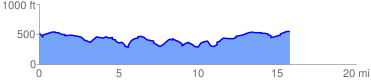
 15.951446 mi
 1237.03 ft
 1222.10 ft
 14.93 ft
 1.47 %
GPX Downloads: Track Route
![]()
| at: |
Sumter National Forest - Long Cane District |
show on map
animate
15.951446 mi
1237.03 ft
1222.10 ft
14.93 ft
1.47 %