| at: |
Sumter National Forest - Long Cane District |
Data from USFS GIS
 show on map
 animate
Trail users:


Elevation Profile
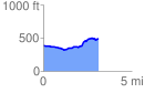
 3.093512 mi
 229.66 ft
 124.88 ft
 104.78 ft
 1.41 %
GPX Downloads: Track Route
![]()
| at: |
Sumter National Forest - Long Cane District |
show on map
animate
3.093512 mi
229.66 ft
124.88 ft
104.78 ft
1.41 %