|
| at: |
Sumter National Forest - Long Cane District |
Data from USFS GIS
 show on map
 animate
Trail users:


Elevation Profile
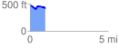
 0.996492 mi
 73.68 ft
 136.26 ft
 -62.57 ft
 2.59 %
GPX Downloads: Track Route
![]()
|
| at: |
Sumter National Forest - Long Cane District |
show on map
animate
0.996492 mi
73.68 ft
136.26 ft
-62.57 ft
2.59 %