| at: |
Sumter National Forest - Long Cane District |
Data from USFS GIS
 show on map
 animate
Trail users:


Elevation Profile
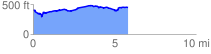
 5.932017 mi
 374.62 ft
 331.90 ft
 42.72 ft
 1.20 %
GPX Downloads: Track Route
![]()
| at: |
Sumter National Forest - Long Cane District |
show on map
animate
5.932017 mi
374.62 ft
331.90 ft
42.72 ft
1.20 %