| at: |
Sumter National Forest - Long Cane District |
Data from USFS GIS
 show on map
 animate
Trail users:


Elevation Profile
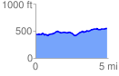
 4.908816 mi
 327.44 ft
 218.60 ft
 108.84 ft
 1.26 %
GPX Downloads: Track Route
![]()
| at: |
Sumter National Forest - Long Cane District |
show on map
animate
4.908816 mi
327.44 ft
218.60 ft
108.84 ft
1.26 %