|
| at: |
Sumter National Forest - Long Cane District |
Data from USFS GIS
 show on map
 animate
Trail users:


Elevation Profile
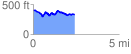
 2.447449 mi
 337.01 ft
 398.51 ft
 -61.50 ft
 3.08 %
GPX Downloads: Track Route
![]()
|
| at: |
Sumter National Forest - Long Cane District |
show on map
animate
2.447449 mi
337.01 ft
398.51 ft
-61.50 ft
3.08 %