|
| at: |
Sumter National Forest - Long Cane District |
Data from USFS GIS
 show on map
 animate
Trail users:


Elevation Profile
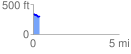
 0.386991 mi
 5.09 ft
 55.84 ft
 -50.74 ft
 2.73 %
GPX Downloads: Track Route
![]()
|
| at: |
Sumter National Forest - Long Cane District |
show on map
animate
0.386991 mi
5.09 ft
55.84 ft
-50.74 ft
2.73 %