| at: |
Sumter National Forest - Long Cane District |
Data from USFS GIS
 show on map
 animate
Trail users:


Elevation Profile
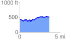
 3.650028 mi
 332.17 ft
 250.74 ft
 81.43 ft
 1.72 %
GPX Downloads: Track Route
![]()
| at: |
Sumter National Forest - Long Cane District |
show on map
animate
3.650028 mi
332.17 ft
250.74 ft
81.43 ft
1.72 %