| at: |
Sumter National Forest - Long Cane District |
Data from USFS GIS
 show on map
 animate
Trail users:


Elevation Profile
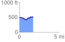
 1.705837 mi
 106.40 ft
 95.04 ft
 11.36 ft
 1.18 %
GPX Downloads: Track Route
![]()
| at: |
Sumter National Forest - Long Cane District |
show on map
animate
1.705837 mi
106.40 ft
95.04 ft
11.36 ft
1.18 %