|
| at: |
Sumter National Forest - Long Cane District |
Data from USFS GIS
 show on map
 animate
Trail users:


Elevation Profile
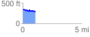
 1.077776 mi
 60.16 ft
 115.09 ft
 -54.93 ft
 2.02 %
GPX Downloads: Track Route
![]()
|
| at: |
Sumter National Forest - Long Cane District |
show on map
animate
1.077776 mi
60.16 ft
115.09 ft
-54.93 ft
2.02 %