| at: |
Sumter National Forest - Long Cane District |
Data from USFS GIS
 show on map
 animate
Trail users:


Elevation Profile
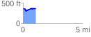
 1.094895 mi
 85.56 ft
 78.89 ft
 6.67 ft
 1.48 %
GPX Downloads: Track Route
![]()
| at: |
Sumter National Forest - Long Cane District |
show on map
animate
1.094895 mi
85.56 ft
78.89 ft
6.67 ft
1.48 %