|
| at: |
Sumter National Forest - Long Cane District |
Data from USFS GIS
 show on map
 animate
Trail users:


Elevation Profile
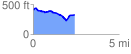
 2.415029 mi
 175.47 ft
 249.49 ft
 -74.01 ft
 1.96 %
GPX Downloads: Track Route
![]()
|
| at: |
Sumter National Forest - Long Cane District |
show on map
animate
2.415029 mi
175.47 ft
249.49 ft
-74.01 ft
1.96 %