| at: |
Sumter National Forest - Long Cane District |
Data from USFS GIS
 show on map
 animate
Trail users:

Elevation Profile
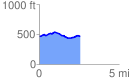
 2.591816 mi
 158.10 ft
 149.97 ft
 8.13 ft
 1.16 %
GPX Downloads: Track Route
![]()
| at: |
Sumter National Forest - Long Cane District |
show on map
animate
2.591816 mi
158.10 ft
149.97 ft
8.13 ft
1.16 %