| at: |
Sumter National Forest - Long Cane District |
Data from USFS GIS
 show on map
 animate
Trail users:


Elevation Profile
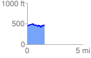
 1.572293 mi
 134.71 ft
 113.22 ft
 21.50 ft
 1.62 %
GPX Downloads: Track Route
![]()
| at: |
Sumter National Forest - Long Cane District |
show on map
animate
1.572293 mi
134.71 ft
113.22 ft
21.50 ft
1.62 %