|
| at: |
Amicalola/Nimblewill/Tickanetley |
Data from USFS GIS
 show on map
 animate
Trail users:

Elevation Profile
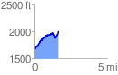
 1.622122 mi
 575.08 ft
 247.75 ft
 327.33 ft
 6.71 %
GPX Downloads: Track Route
![]()
|
| at: |
Amicalola/Nimblewill/Tickanetley |
show on map
animate
1.622122 mi
575.08 ft
247.75 ft
327.33 ft
6.71 %