| at: |
Cohutta Pinhoti |
Data from David Muse
 show on map
 animate
Trail users:


Elevation Profile
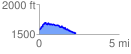
 2.297592 mi
 258.35 ft
 306.95 ft
 -48.60 ft
 2.53 %
GPX Downloads: Track Route
![]()
| at: |
Cohutta Pinhoti |
show on map
animate
2.297592 mi
258.35 ft
306.95 ft
-48.60 ft
2.53 %