| at: |
Lake Russell WMA |
Data from Positive Flow
 show on map
 animate
Trail users:


Elevation Profile
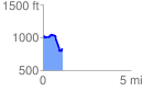
 1.114712 mi
 111.71 ft
 301.62 ft
 -189.92 ft
 5.12 %
GPX Downloads: Track Route
![]()
| at: |
Lake Russell WMA |
show on map
animate
1.114712 mi
111.71 ft
301.62 ft
-189.92 ft
5.12 %