| at: |
Lake Russell WMA |
Data from Positive Flow
 show on map
 animate
Trail users:


Elevation Profile
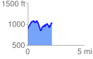
 2.140756 mi
 711.56 ft
 553.81 ft
 157.75 ft
 6.30 %
GPX Downloads: Track Route
![]()
| at: |
Lake Russell WMA |
show on map
animate
2.140756 mi
711.56 ft
553.81 ft
157.75 ft
6.30 %