| at: |
Harbison State Forest |
Data from David Muse
 show on map
 animate
Trail users:


Elevation Profile
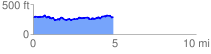
 5.017821 mi
 546.34 ft
 552.20 ft
 -5.86 ft
 2.08 %
GPX Downloads: Track Route
![]()
| at: |
Harbison State Forest |
show on map
animate
5.017821 mi
546.34 ft
552.20 ft
-5.86 ft
2.08 %