| at: |
Harbison State Forest |
Data from David Muse
 show on map
 animate
Trail users:


Elevation Profile
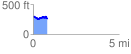
 0.844307 mi
 113.46 ft
 136.38 ft
 -22.93 ft
 3.06 %
GPX Downloads: Track Route
![]()
| at: |
Harbison State Forest |
show on map
animate
0.844307 mi
113.46 ft
136.38 ft
-22.93 ft
3.06 %