| at: |
Paynes Creek Recreation Area |
Data from Lush S
 show on map
 animate
Trail users:


Elevation Profile
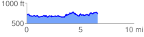
 6.774674 mi
 1347.08 ft
 1349.01 ft
 -1.94 ft
 3.77 %
GPX Downloads: Track Route
Trailheads:
 Paynes Creek Recreation Area Boat Ramp Lot