|
| at: |
Blue Ridge WMA |
Data from David Muse
 show on map
 animate
Trail users:


Elevation Profile
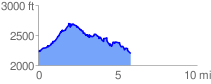
 5.921756 mi
 1623.73 ft
 1654.46 ft
 -30.73 ft
 5.29 %
GPX Downloads: Track Route
![]()
|
| at: |
Blue Ridge WMA |
show on map
animate
5.921756 mi
1623.73 ft
1654.46 ft
-30.73 ft
5.29 %