|
| at: |
Blue Ridge WMA |
Data from David Muse
 show on map
 animate
Trail users:


Elevation Profile
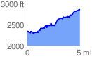
 4.724010 mi
 1200.36 ft
 658.39 ft
 541.97 ft
 4.81 %
GPX Downloads: Track Route
![]()
|
| at: |
Blue Ridge WMA |
show on map
animate
4.724010 mi
1200.36 ft
658.39 ft
541.97 ft
4.81 %