| at: |
Anne Springs Close Greenway |
Data from Positive Flow
 show on map
 animate
Trail users:


Elevation Profile
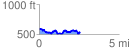
 2.587354 mi
 394.43 ft
 485.92 ft
 -91.49 ft
 3.56 %
GPX Downloads: Track Route
![]()
| at: |
Anne Springs Close Greenway |
show on map
animate
2.587354 mi
394.43 ft
485.92 ft
-91.49 ft
3.56 %