|
| at: |
Blue Ridge WMA |
Data from David Muse
 show on map
 animate
Trail users:


Elevation Profile
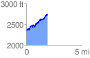
 1.931354 mi
 652.90 ft
 245.57 ft
 407.33 ft
 6.40 %
GPX Downloads: Track Route
![]()
|
| at: |
Blue Ridge WMA |
show on map
animate
1.931354 mi
652.90 ft
245.57 ft
407.33 ft
6.40 %