| at: |
Sesquicentennial State Park |
Data from Positive Flow
 show on map
 animate
Trail users:


Elevation Profile
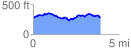
 3.956166 mi
 373.84 ft
 383.21 ft
 -9.36 ft
 1.83 %
GPX Downloads: Track Route
![]()
| at: |
Sesquicentennial State Park |
show on map
animate
3.956166 mi
373.84 ft
383.21 ft
-9.36 ft
1.83 %