|
| at: |
Blue Ridge WMA Bull/Jake Mountain |
Data from David Muse
 show on map
 animate
Trail users:


Elevation Profile
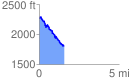
 1.562959 mi
 147.69 ft
 618.02 ft
 -470.33 ft
 7.49 %
GPX Downloads: Track Route
![]()
|
| at: |
Blue Ridge WMA Bull/Jake Mountain |
show on map
animate
1.562959 mi
147.69 ft
618.02 ft
-470.33 ft
7.49 %