| at: |
Sipsey Wilderness |
Data from USFS GIS
 show on map
 animate
Trail users:


Elevation Profile
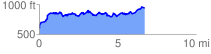
 6.819417 mi
 1536.49 ft
 1189.29 ft
 347.20 ft
 4.27 %
GPX Downloads: Track Route
![]()
| at: |
Sipsey Wilderness |
show on map
animate
6.819417 mi
1536.49 ft
1189.29 ft
347.20 ft
4.27 %