|
| at: |
Tuskegee National Forest |
Data from USFS GIS
 show on map
 animate
Trail users:


Elevation Profile
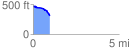
 0.979628 mi
 19.65 ft
 170.97 ft
 -151.32 ft
 3.31 %
GPX Downloads: Track Route
![]()
|
| at: |
Tuskegee National Forest |
show on map
animate
0.979628 mi
19.65 ft
170.97 ft
-151.32 ft
3.31 %