|
| at: |
Tuskegee National Forest |
Data from USFS GIS
 show on map
 animate
Trail users:


Elevation Profile
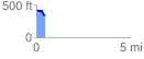
 0.488018 mi
 17.35 ft
 96.09 ft
 -78.74 ft
 3.73 %
GPX Downloads: Track Route
![]()
|
| at: |
Tuskegee National Forest |
show on map
animate
0.488018 mi
17.35 ft
96.09 ft
-78.74 ft
3.73 %