|
| at: |
Tuskegee National Forest |
Data from USFS GIS
 show on map
 animate
Trail users:


Elevation Profile
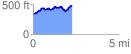
 2.266031 mi
 310.50 ft
 162.47 ft
 148.03 ft
 2.60 %
GPX Downloads: Track Route
![]()
|
| at: |
Tuskegee National Forest |
show on map
animate
2.266031 mi
310.50 ft
162.47 ft
148.03 ft
2.60 %