|
| at: |
Tuskegee National Forest |
Data from USFS GIS
 show on map
 animate
Trail users:


Elevation Profile
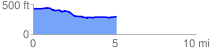
 5.127500 mi
 90.25 ft
 219.88 ft
 -129.64 ft
 0.81 %
GPX Downloads: Track Route
![]()
|
| at: |
Tuskegee National Forest |
show on map
animate
5.127500 mi
90.25 ft
219.88 ft
-129.64 ft
0.81 %