|
| at: |
Tuskegee National Forest |
Data from USFS GIS
 show on map
 animate
Trail users:


Elevation Profile
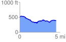
 4.556418 mi
 313.53 ft
 436.20 ft
 -122.67 ft
 1.81 %
GPX Downloads: Track Route
![]()
|
| at: |
Tuskegee National Forest |
show on map
animate
4.556418 mi
313.53 ft
436.20 ft
-122.67 ft
1.81 %