|
| at: |
Tuskegee National Forest |
Data from USFS GIS
 show on map
 animate
Trail users:


Elevation Profile
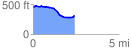
 2.400715 mi
 94.03 ft
 242.59 ft
 -148.56 ft
 1.91 %
GPX Downloads: Track Route
![]()
|
| at: |
Tuskegee National Forest |
show on map
animate
2.400715 mi
94.03 ft
242.59 ft
-148.56 ft
1.91 %