|
| at: |
Tuskegee National Forest |
Data from USFS GIS
 show on map
 animate
Trail users:


Elevation Profile
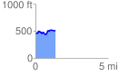
 1.350441 mi
 155.23 ft
 125.26 ft
 29.96 ft
 2.18 %
GPX Downloads: Track Route
![]()
|
| at: |
Tuskegee National Forest |
show on map
animate
1.350441 mi
155.23 ft
125.26 ft
29.96 ft
2.18 %