|
| at: |
Conecuh National Forest |
Data from USFS GIS
 show on map
 animate
Trail users:


Elevation Profile
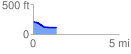
 1.391105 mi
 3.69 ft
 103.56 ft
 -99.87 ft
 1.41 %
GPX Downloads: Track Route
![]()
|
| at: |
Conecuh National Forest |
show on map
animate
1.391105 mi
3.69 ft
103.56 ft
-99.87 ft
1.41 %