|
| at: |
Conecuh National Forest |
Data from USFS GIS
 show on map
 animate
Trail users:


Elevation Profile
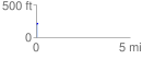
 0.083703 mi
 8.30 ft
 6.34 ft
 1.96 ft
 1.88 %
GPX Downloads: Track Route
![]()
|
| at: |
Conecuh National Forest |
show on map
animate
0.083703 mi
8.30 ft
6.34 ft
1.96 ft
1.88 %