|
| at: |
Conecuh National Forest |
Data from USFS GIS
 show on map
 animate
Trail users:


Elevation Profile
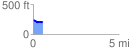
 0.557943 mi
 19.14 ft
 48.77 ft
 -29.63 ft
 1.66 %
GPX Downloads: Track Route
![]()
|
| at: |
Conecuh National Forest |
show on map
animate
0.557943 mi
19.14 ft
48.77 ft
-29.63 ft
1.66 %