|
| at: |
Conecuh National Forest |
Data from USFS GIS
 show on map
 animate
Trail users:


Elevation Profile
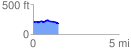
 1.487845 mi
 66.58 ft
 86.53 ft
 -19.95 ft
 1.10 %
GPX Downloads: Track Route
![]()
|
| at: |
Conecuh National Forest |
show on map
animate
1.487845 mi
66.58 ft
86.53 ft
-19.95 ft
1.10 %