|
| at: |
Conecuh National Forest |
Data from USFS GIS
 show on map
 animate
Trail users:


Elevation Profile
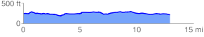
 13.021963 mi
 463.74 ft
 498.28 ft
 -34.53 ft
 0.72 %
GPX Downloads: Track Route
![]()
|
| at: |
Conecuh National Forest |
show on map
animate
13.021963 mi
463.74 ft
498.28 ft
-34.53 ft
0.72 %