| at: |
Conecuh National Forest |
Data from USFS GIS
 show on map
 animate
Trail users:


Elevation Profile
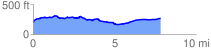
 7.959327 mi
 424.89 ft
 366.21 ft
 58.68 ft
 1.01 %
GPX Downloads: Track Route
![]()
| at: |
Conecuh National Forest |
show on map
animate
7.959327 mi
424.89 ft
366.21 ft
58.68 ft
1.01 %