|
| at: |
Bankhead National Forest |
Data from USFS GIS
 show on map
 animate
Trail users:


Elevation Profile
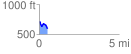
 0.530465 mi
 43.16 ft
 170.09 ft
 -126.94 ft
 6.07 %
GPX Downloads: Track Route
![]()
|
| at: |
Bankhead National Forest |
show on map
animate
0.530465 mi
43.16 ft
170.09 ft
-126.94 ft
6.07 %