|
| at: |
Bankhead National Forest |
Data from USFS GIS
 show on map
 animate
Trail users:


Elevation Profile
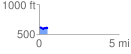
 0.524610 mi
 62.39 ft
 78.69 ft
 -16.31 ft
 2.84 %
GPX Downloads: Track Route
![]()
|
| at: |
Bankhead National Forest |
show on map
animate
0.524610 mi
62.39 ft
78.69 ft
-16.31 ft
2.84 %