|
| at: |
Bankhead National Forest |
Data from USFS GIS
 show on map
 animate
Trail users:


Elevation Profile
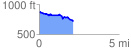
 2.146404 mi
 103.30 ft
 254.75 ft
 -151.45 ft
 2.25 %
GPX Downloads: Track Route
![]()
|
| at: |
Bankhead National Forest |
show on map
animate
2.146404 mi
103.30 ft
254.75 ft
-151.45 ft
2.25 %