|
| at: |
Bankhead National Forest |
Data from USFS GIS
 show on map
 animate
Trail users:


Elevation Profile
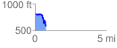
 0.769097 mi
 72.13 ft
 297.67 ft
 -225.55 ft
 7.33 %
GPX Downloads: Track Route
![]()
|
| at: |
Bankhead National Forest |
show on map
animate
0.769097 mi
72.13 ft
297.67 ft
-225.55 ft
7.33 %