|
| at: |
Bankhead National Forest |
Data from USFS GIS
 show on map
 animate
Trail users:


Elevation Profile
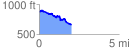
 2.006483 mi
 134.82 ft
 353.94 ft
 -219.12 ft
 3.34 %
GPX Downloads: Track Route
![]()
|
| at: |
Bankhead National Forest |
show on map
animate
2.006483 mi
134.82 ft
353.94 ft
-219.12 ft
3.34 %