|
| at: |
Bankhead National Forest |
Data from USFS GIS
 show on map
 animate
Trail users:


Elevation Profile
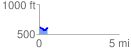
 0.523148 mi
 51.38 ft
 57.76 ft
 -6.38 ft
 2.09 %
GPX Downloads: Track Route
![]()
|
| at: |
Bankhead National Forest |
show on map
animate
0.523148 mi
51.38 ft
57.76 ft
-6.38 ft
2.09 %