|
| at: |
Bankhead National Forest |
Data from USFS GIS
 show on map
 animate
Trail users:


Elevation Profile
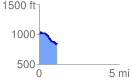
 1.138994 mi
 68.52 ft
 211.47 ft
 -142.96 ft
 3.52 %
GPX Downloads: Track Route
![]()
|
| at: |
Bankhead National Forest |
show on map
animate
1.138994 mi
68.52 ft
211.47 ft
-142.96 ft
3.52 %