|
| at: |
Bankhead National Forest |
Data from USFS GIS
 show on map
 animate
Trail users:


Elevation Profile
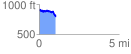
 1.038457 mi
 114.28 ft
 212.42 ft
 -98.14 ft
 3.87 %
GPX Downloads: Track Route
![]()
|
| at: |
Bankhead National Forest |
show on map
animate
1.038457 mi
114.28 ft
212.42 ft
-98.14 ft
3.87 %