|
| at: |
Bankhead National Forest |
Data from USFS GIS
 show on map
 animate
Trail users:


Elevation Profile
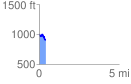
 0.422737 mi
 43.45 ft
 123.36 ft
 -79.91 ft
 5.53 %
GPX Downloads: Track Route
![]()
|
| at: |
Bankhead National Forest |
show on map
animate
0.422737 mi
43.45 ft
123.36 ft
-79.91 ft
5.53 %